
Day 46: 102 miles to campground, and then 56 miles back and forth to Aunt Dawns
Starting location: Gilbert Ray Campground, Tucson Mountains Park, Arizona – 60 degrees
Ending location: Jim Kortsen West Pinal Park, Maricopa Arizona – 75 degrees
Major Stops: None
Weather: Sunny
Days 47-49: Back and forth to Aunt Dawn’s
Major Activities: Visiting, Pizza party and laundry
Day 50: 103
Starting location: Jim Kortsen West Pinal Park, Maricopa Arizona – 65 degrees
Ending location: Picket Post Mountain boondock – 60 degrees
Major Stops: Oregano’s for lunch with Ron and family; Aldi’s, Wine World and Petsmart
Weather: Sunny
Day 51: 61 Miles
Starting location: Picket Post Mountain boondock, Superior, Arizona – 50 degrees
Ending location: Cholla Campground, Roosevelt Lake, Arizona – 68 degrees
Major Stops: Walmarts, Gas and Carwash
Weather: Sunny
Days 52-57: Around area
Major Activities: Hiking, Reading and visiting Tonto Natural Bridge
Leaving Saguaro National Park area we headed to a campground called West Pinal Park which is 20+ miles west of Casa Grande where my Aunt Dawn (Mom’s sister) and her daughter and family live. Dottie and I spent the next four days visiting with relatives, driving back and forth from the remote campground across cow country.
This is my Aunt Dawn. For some reason, I did not get any pictures of my cousins and family. Sorry Sarah and Steve…. I really enjoyed my visit with you all, and thank you for making the time to see me!

I also did not manage to get any pictures, but there were huge fenced in fields along the highway on both sides where cows stretched as far as I could see. They were the black and white dairy type of cows. Fortunately, you could not smell them from the campground as they started a few miles east of it. Honestly, I felt sorry for them as they stood around in their muck. Interestingly, and I guess it makes sense from a cows standpoint, but they also grow Michigan type grass in huge fields…in Arizona!? You could see the pollution (methane?) literally over the fields.
Another Boondock
Leaving Casa Grande area, I met up with another cousin (Ron) from my Aunt’s family, in the Queen Creek area (east and south of Mesa). We had a lovely lunch and catch up at Oregano’s restaurant. Then I did the chore thing getting groceries for me, and dog food for Dottie. I did my laundry at Aunt Dawn’s (thank you!) so no need for that. Don’t laugh, but this was my first stop at an Aldi’s. I got snuckered into buying what I thought were wheat thins…but they were “thin wheats” in a look alike book. They taste ok…just not quite the same.
I had planned to spend another night in West Pinal, but since I drove up to Queen Creek to meet Ron and his family when it worked for him, it did not make sense to drive back the 62 miles only to drive it again in the morning since my next campground was in this direction. So, I found this lovely little boondocking spot near Superior Arizona and spent a lovely and quiet night.


Cholla Campground
Next morning, we stopped in Globe at Walmart for a few more items that Aldi did not have, filled the gas tank, washed Clarice at a lovely carwash that took a credit card, and headed to Tonto National Forest and Roosevelt Lake.


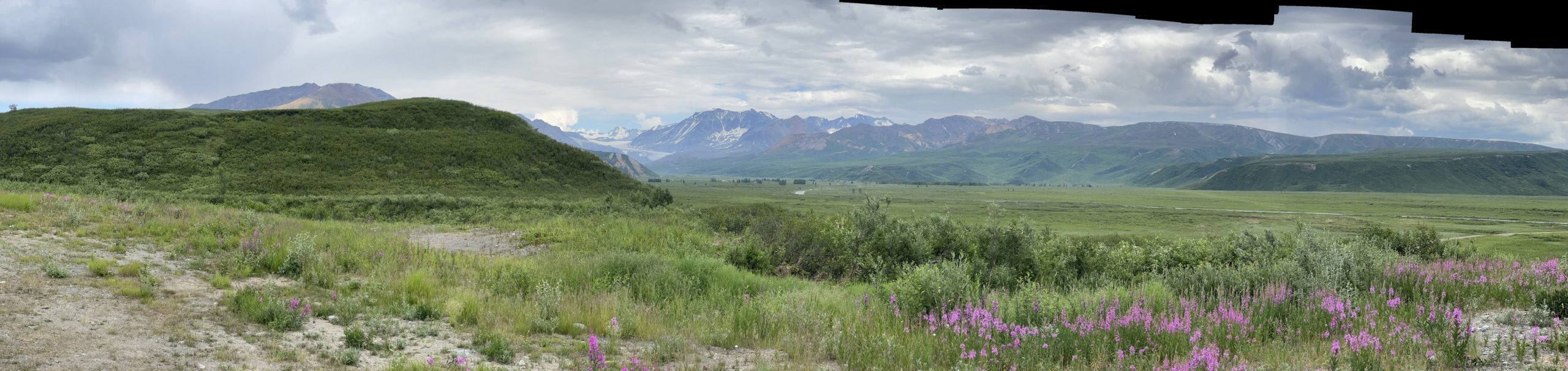
Unfortunately there was no place to stop and take a picture. This lake takes your breath away when you come over the mountains and see it completely from on high. I recommend that drive!


Hiking in Cholla
Eager to get our hike on, I woke Dottie early the next morning.


One thing about this campground, even though the sites are close, you feel fairly secluded with the vegetation.
Tonto Natural Bridge
The campground host told us about the sights to see in area. One of the sites was the Tonto Natural Bridge about 60 miles north. So, tired of being in one place for a while, we decided to take the drive and see it.


There are trails to the bottom. Unfortunately, I was not allowed to leave Dottie unattended in the vehicle, even though she would have climate control (and it was 50 degrees!). It’s an Arizona law and the park ranger was adamant that I understood this. Dottie was only allowed on the trails around the top.


A few days later, this area got 8 inches of snow! Oh, and we refilled propane in Payson the town just south of the bridge at the 76 gas station; and, I ate fast food for the second or maybe third time on the entire trip. I was dying for a Wendy’s chicken sandwich and fries, so I caved. I love those things!
The BIG Hike
There were trails all around the Cholla area but mostly they were “forest” access roads. So, Dottie and I set off to do one of these roads that did a nice loop starting on one side of the campground area and finishing on the other side. It seemed perfect! It was FR (Forest Road) 647 also known as Game Loop.
We headed out of the campground, turned to the south and hiked down the road about a mile to the head of the FR. There we found two Arizona Wildlife and Game employees and a volunteer observing a pair of eagles with a nest. Arizona is not blessed with the eagles we have in Michigan and they are working to help them survive here. There are six pairs in the Tonto area, and since Roosevelt Lake is huge (22.4 miles long) and surrounded by mountains, this seems a small population to me.


Other than a dirt bike the only BLM campers were near the main road where this road was somewhat passable(?). Even a 4WD high clearance vehicle would have a tough time on this road.


I’m so impressed, what an adventure you are on. So beautiful!
Thanks, Sherry! I hope all is going well for you on your new journey, too! Loving it!
Karen, I finally got caught up on all your posts from your trip. This is March 8 and our last day in Arizona before heading back to Michigan and decided to relax. Doug and I enjoyed your pictures and comments. What an awesome trip! We just came from Tucson where we hiked Sabino canyon. I look for Clarise whenever we’re by a campground. Can’t wait to read your next post! I miss you! Carol K
Ah, Carol thank you for your sweet words. I wish I’d known as could have redirected to swing through. You’ll understand when I post the next blog. Miss you, too! Hope you had a fantastic time!
Wow Roosevelt Lake is absolutely beautiful. What a hike though!sounds awesome!
Take care Karen!!!😀