
I’m finding more areas without cell service or very weak service than I expected. For this next leg of the trip, I had anticipated a lack of service and the need to monitor Clairce’s temperature to keep Dottie safe, so I set up my new Zoleo while at Sandy Creek when I had good service. Zoleo is a satellite communicator that will allow me to send a check in with my location, SOS signal if I get in trouble, and it will even send text messages to anyone I wish from basically anywhere in the outside world at a steep cost. Just to be clear, it will not work in a cave or underwater, as it must be pointed towards the sky to pick up a satellite. So, at Seminole Canyon I was able to test Zoleo out before I even entered the most remote area. She works beautifully!
More Propane Fun
Running heat most nights since leaving the Trace, I wanted to fill the propane tank before heading into the deep wilderness. A nice couple told me to pick up everything I would need before leaving Sanderson, as once turning south there would be nothing. They even told me where to get my propane fill. So, I stopped at the cute little white and blue propane station after getting gas. Unfortunately, their equipment was broken so I was unable to fill up. There was one more town coming up before turning south, and it looked like they would have propane. So, I tried to find the place and could not. Then, I called their number and learned, they were indeed there (somewhere!), but they were out of propane, and so was everyone in the town! The next town was another 30 miles away, so since I had 1/2 tank, I decided to risk it.
The Big Reveal
If you have been tracking me on a map, this will not be a shock. Or, if you talked to me about my plans, as this place was top of the list after the Trace. Dottie and I drove south to (drum roll, please):

The Visitors Center at Persimmon Gap was closed, so we drove on the 30+ miles to Panther Junction where the Visitors Center was open. (Covid changes everything!) I picked up my official map and purchased a National Park Passport book. I have solved the whole little souvenir thing. Originally, I was going to get a little magnet to put on my refrigerator. Then I learned, that the RV fridge will not hold a magnet! So, this little book will allow me to just get a sticker and put it in my passport book. That’s even lighter than a magnet! Win/win!
Day 17: 209 Miles
Starting location: Seminole Canyon State Park, Comstock, Texas – 35 degrees
Ending location: Chisos Basin Campground, Big Bend National Park, Texas – 65 degrees
Major Stops: None
Weather: Cloudy and cool early, becoming sunny and warmer in afternoon
Day 18: 0 Miles – Chisos Basin Campground
Hike: Window Trail 5.0 miles, 980 feet elevation
Day 19: 0 Miles – Chisos Basin Campground
Hike: Basin Loop 3.2 miles including hike from campground
Chisco Basin Area
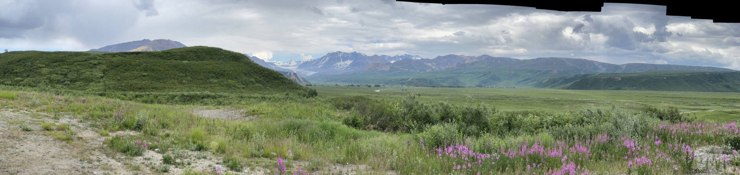
Leaving the visitors center, I headed west to Chisos Basin Junction and made the turn onto the road. The official map says, “not recommended for trailers longer than 20 feet and RV’s over 24 feet due to sharp curves and steep grades”. They mean it! You climb from about 3700 feet to 5400 over six miles with plenty of 10 mph curves. The other thing you see as you enter the area is this:

Here are some pictures of the campground area.


Now this is the shocker! We had cell service! 2 bars and not great, but I was able to get a post out and do some more planning. So, enough. I was also able to talk to Victoria and do my check in’s with the fam on cell versus satellite.
One sad thing about National Parks, Dottie is prohibited from hiking on any trails. She is relegated to the paved roads, campgrounds and primitive roads. So, needing her evening puppy potty walk, we walked up to the top of the hill on the paved roads and were lucky enough to see the sunset colors from what is called “The Window”. There is a trail for this, but we found our own little spot at the end of the road!

Hiking
We had three nights in Chisco Basin and I was planning to do some hiking the next day. So, I had a little work to set up a couple of other purchases I made to keep Dottie safe. I had purchased a temperature monitor and gateway that will send me notifications if the temperature inside Clarice gets above a set level. The rig will run air conditioning for 8-10 hours on a full charge with an auto temperature setting. Clarice also has an auto start generator if the batteries get too low. So, I got all that equipment working, AC on, and auto-start set the next morning. Then I headed out to hike the Window trail. Not the view trail, like we saw last night, but down to the actual V of the window.
Here are a bunch of pictures from the hike.

Starting off heading down 
Along the trail 
What a great day! 
Hiking through a canyon 
There was some boulder scambling 
Oh, to have 20 year old knees again! 
These were put in in the 1930’s!
And this is what you find at the end of the trail.

See the hole in the rock towards the outer edge. People will climb down into that hole. I’m too chicken for that, so my pictures are from a safe distance.

Basin Loop
I really wanted to do the Lost Mine Trail. However, after the 980 feet on the windows trail, my knees were hurting, and the Lost Mine has 1100 feet of elevation gain. So, the next day, I did the Basin Loop trail which only has 350 feet of elevation. I don’t want to blow out my knees so early in the journey. Here are a couple of shots from that hike. One will look familiar as I hiked to it the day before.

Basin Loop view 
The window from up higher
Hey Karen! I’m not sure that my messages are getting through to you, but I love your blog! So glad that you can take this trip with Dottie!
Thanks, Ellen! When I can get cell, I can see your messages. Thanks for your very kind comments. I’m so glad you are enjoying it. It has been fun to document the trip and Dottie and I are really having a blast. She is thankful for State Parks and National Forest lands thought as she can hike there.
I do miss the soft trails of Michigan! These southern trails are very rocky!
Love The Window at sunset! Hope your knees are hanging in there.
Thanks, Sally! So far, so good! We climbed a mountain yesterday…or so it felt! More to come on that later. 🙂
We’ve had some beautiful sunsets and the stars are amazing!
Beautiful!