
Where is Karen?
Apologies for being absent so long. I will give you many more details in a subsequent post; the short story is that I had a friend come out to travel with me for a couple of weeks. So, I’ve been spending time with her; and, frankly cell service has been much spottier than I expected it to be in California.
So, back to the journey……
Starting location: River Island State Park, Parker AZ – 70 degrees
Ending location: Buckskin Mountain State Park, Parker AZ – 82 degrees; 2 nights
Miles: 55 miles
Major Stops: Lake Havasu, Parker Dam
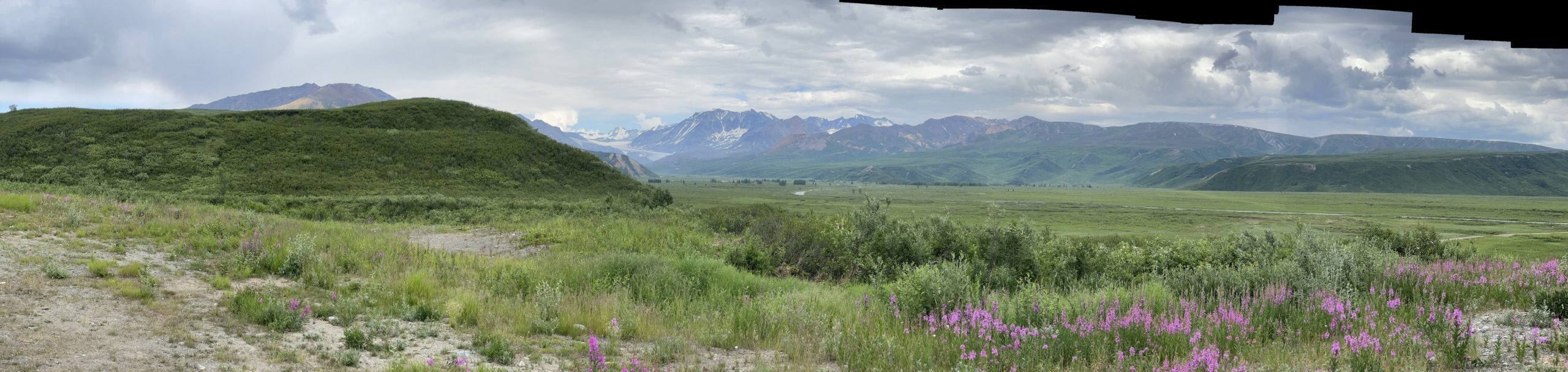
Hikes: Buckskin Mountain Loop trail – 2.1 miles
Weather: Sunny, High 82, low in the upper 50’s.
Buckskin Mountain State Park is a sister park to River Island and is only 2 miles south of it. So, having some time to kill between checkout and check in, we went up to Lake Havasu to see it, wash Clarice, find cell service and pick up a few groceries.
Parker Dam
Lake Havasu is formed by the Parker Dam on the Colorado river.


Lake Havasu
I did not take any pictures of the city, as…well, I’m just not much of a city girl and frankly, it was just a lot of strip malls. However, they do have the London Bridge, …..the original one. NOT kidding! Because it was just plain busy and traffic was terrible, I was not able to park. So, no picture by me, but here is an article on the topic.
Here are some pictures of the south end of Lake Havasu where I was able to find a turn off. The lake is quite large; according to Google it is 26.3 miles long and 2.85 miles wide at its widest.


Buckskin Mountain
The campground here is a bit older and not quite as nice as River Island, however, Dottie was able to hike with me and walk on the non-swimming beach which was a bonus for her. And, both parks had DOG PARKS for off leash! Dottie LOVED IT!


Leaving the Desert
Starting location: Buckskin Mountain State Park, Parker AZ – 75 degrees
Ending location: Serrano Campground, Fawnskin, CA – 58 degrees – 8 nights
Miles: 211 miles
Major Stops: None
Hikes: Cougar Crest Trail – 5.6 miles; Bike Path daily hikes 2-4 miles depending on the day.
Weather: Sunny, Highs 55-68, lows in the upper 30’s.
We are heading now to the mountains and Big Bear Lake! So, we drove back across the desert and went through Twentynine Palms again, like we did going to and from Joshua Tree. This time we kept going west out of Twentynine Palms and turned up into the mountains at Yucca Valley.
Clarice had to work very hard to go up to the campground which sits at 6800 feet. It involved a lot of hair pin turns and pulling over to let the smaller vehicles go past. As we drove around Baldwin Lake, I wondered if there would be any water. It was dried up completely! I was very happy to see water in Big Bear as we got to the campground area! Many areas were dried up and docks were sitting on the ground rather than floating.

Serrano Campground
The campground is a National Forest Campground and is quite large with 109 sites on several loops. It is not directly on the lake, but sits adjacent to the road and has several trails that lead you to the lake.


Solar Observations
The park sits next to some very large telescopes used to study the sun. Here is some very interesting information about them.


Bike Path and Coyote!
There is a wonderful paved path along the whole northern edge of the lake going into Bear Lake City. Dottie and I walked it quite often and enjoyed it immensely!


Tree Love!
We learned about the difference between a Ponderosa Pine and a Jeffrey Pine; and, the age of these amazing trees all along the trail! Here is some of the signage they provided and some pictures of the amazing trees!


A Surprise Visitor!
A dear friend surprised me when he texted to say he was also in Southern California visiting his father and would be there for a few more days. He made the 2.5 hour drive up (5 hours round trip!); and, we took a lovely walk along the lake, had a great visit and a delicious lunch in Big Bear. This was my first real restaurant (not fast food) since I left home! While walking along the lake, we learned they stock it with trout, and we watched some people fishing for them.
Please meet Shawn!


Cougar Crest Trail
Dottie was able to hike in the National Forest, so we took a highly recommended trail and had a beautiful hike. The Cougar Crest Trail connects to the Pacific Crest Trail (PCT) at its end. The PCT is one of the triple crowns for hikers in the US, along with the Appalachian Trail (AT) and Continental Divide trail (CDT). It was a bucket list hike I wanted to do when I bought all the backpacking equipment. Unfortunately, my knees and arthritis will not allow me to add 40-50 lbs on my back and hike over 2,000 miles. But, I was thrilled to be able to set my feet on it and hike a few hundred feet.


The mountains look so beautiful! How nice to have visit from Shawn! That’s awesome to see the Pacific Crest Trail! Did you read the book ‘Wild’ or see the movie? It’s worth reading/watching. I was glad to see a new update on your travels.🤗
Thanks, Sue! I did read the book and loved it. Martha F. lent it to me.
Love the photo of happy you back in the trees!!!
Thanks, Sally! 🙂
How awesome Shawn was able to meet you! Love your adventures
Thanks, Tammy!
Are you done now? Can’t wait to hear your adventures!
Awesome trip! My niece is starting the PCT in a couple days! She plans to do the whole thing. She’s young 🙂
Can’t wait to see how she does! I hope it goes well for her, Jaq!
I very much enjoyed our visit. I love being in the mountains. I feel closer to God there.
Was so delighted to spend a little time with you! I loved your visit! Thanks for coming, Shawn!
Thanks for the update it looks wonderful! So pleased for you.
Thanks, Tricia! Hope all is well on your end.
Wonderful pictures Karen! I can almost smell the pine trees. So glad you’re having a fantastic time! And how fun to have seen Shawn! He looks just as great as you do!
Thanks Ellen. Retirement is treating me well.
Thanks, Ellen! Those trees sure did smell good after the dust of the desert! 🙂