
Leaving our lovely Tazlina river site, we headed north on the Richardson highway and turned west onto the Denali highway at Paxson (population 10, so don’t think it’s a big place). While the Denali highway is 134 miles long, only the first 21 miles are paved (east to west) and then it becomes gravel until the last 3 miles on the west side are once again paved. Since my friend Christie cautioned me that she has experienced flat tires on this road, I took the cautious approach and we did an in and out on the paved road.
Camping in Alaska
I don’t remember if I have mentioned the camping rules in Alaska, so forgive me if I am repeating. I would love camping to be this way everywhere! Outside of RV parks, which take reservations, most campgrounds are first come first serve; but, even better than that, any pull off that is not marked with “No camping” or Private Property” type signage is fair game for what people call primitive camping. If there is a drive off the road you will often find a fire ring, and a place to camp. The only downside is that means no resources, and you must pack your trash out. But, best of all, it’s free camping and usually beautiful to boot.
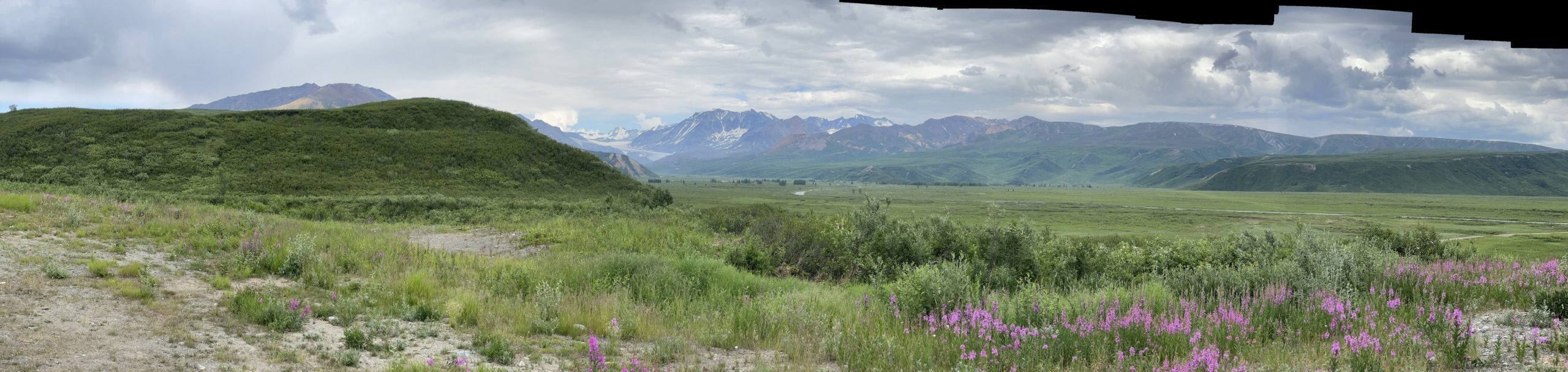
Camping on the Denali Highway
So, I had not gone very far, just a couple of miles on the Denali highway when we found a relatively large and level pull out at the top of a hill with amazing views. We spent 2 nights at this pull out. Now you may be asking yourself, “why would she camp right by a highway?” The answer is this: Alaska highways are not like the lower 48 states highways. If a car went by every 20-30 minutes that was surprising. After dark, no one goes by. So, believe it or not, it is quieter than any campground I’ve ever stayed in. And with views like these….who could resist just staring at those mountains for hours? Plus, we had good cell service here which I confess was shocking.


Sunset
Daylight is killing my sleep patterns. It just doesn’t get dark. At this point in time the sun was setting at 12:17am and rising at 3:59am. Yes, that is less than 4 hours of “dark”; and it’s really twilight during those “dark” hours. And, those who know me well, know that I go to bed early and get up early. So, for me to witness this next picture, I will confess to cranking some music, sipping some wine and having a sunset party looking at those mountains. You may notice, they are missing in the picture. This should have been a clue for me… could the wine have had something to do with my missing this fact as we went to bed?

Wildfires and Smoke
Next morning, we awoke to smoke and could not see the mountains. Sadly it smelled like sitting downwind of a campfire constantly. We stayed that day hoping it would dissipate to allow us to see the scenery for our drive, and while it improved, it did not go away. This picture is after the second night as we drove the rest of the way to the end of the pavement and turned around. It had improved, as we are seeing some mountains in this picture, but it was still not nice to breathe.

Christie had provided me a resource to track the wildfires that also provides a smoke forecast. We were not close to the fires, but we sure had the smoke. Huge learning for me that you did not need to be close to the actual fire. And, the area impacted is huge! (Thank you, Christie for your guidance!)


Delta Junction
Leaving the highway, there is fabulous scenery as you drive over Isabel pass. Unfortunately the smoke was not helpful to enjoying it; and, my daughter had someone scamming her. Communicating via satellite is slower than text, so I needed to get to cell coverage. I lost cell service driving out the rest of the Denali highway and it did not come back where I’d had it previously, go figure! So, I drove to Delta Junction (120 miles) to get signal and help Victoria deal with all that mess. Painful! (Best amazing news, she got her money back this week as she reacted fast enough!)
Since it was the 4th weekend, plus it took a couple of days to sort out identify stuff, I stayed put for a while. I did a lot of this:

End of the Alaska Highway!
Delta Junction has a large military base south of it and is the end of the Alaska highway. Now I must confess, that we did not drive the entire Alaska highway. If you recall, we left it to drive to Skagway and then took the ferry to Haines driving back up the Haines highway. Additionally, we took the Tok cutoff to go south to Valdez so we left the ALCAN at Tok.
On our return trip, we will drive the portion we missed on the Skagway-ferry-Haines section, but we will miss the portion from Delta Junction to Tok. So, we will have missed 108 miles in total. Nonetheless, I am giving myself full credit without remorse! We just took a long detour to get to the end. It’s a long remote drive!


Beautiful mountains! Too bad about all the forest fires and smoke! The sunset pictures are awesome!
Thanks, Sue! The smoke has been a big learning for me. Also, I’m usually more of a sunrise person, but that’s even harder to see then that sunset was! 🙂 I suspect the smoke made it more colorful.
So glad you were able to see one of my favorite places in AK but sorry it was cut short. There are many beautiful places there so I’m looking forward to following your journey and maybe meeting up there in August!
Thanks, Christie! Looking forward to seeing you and your family!
Karen! Just love following your travels! Kay
Thanks, Kay! It’s definitely the trip of a lifetime.
Thank you for posting more mountain pictures Karen! I don’t know how you ever take your eyes off of them to drive! Glad Victoria’s situation was straightened out. Had to be terrifying for her. Enjoy your hammock time!